Use a delivery radius when routes around your takeaway are similar and you want a simple boundary. Choose postcode delivery zones when traffic, river crossings or local access make some addresses harder to serve. Before choosing either, compare real routes during your busiest shifts and test what customers see at checkout.
It’s Friday at 7pm. One customer lives 1.6 miles away across a river. Another lives 2.4 miles away along a main road. The first address falls inside your two-mile circle, but the second may be quicker to reach.
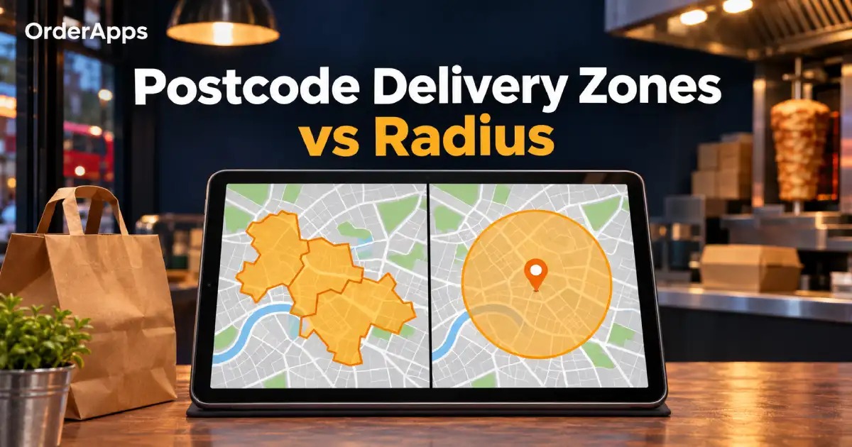
That is the practical difference between postcode delivery zones and a delivery radius. The circle gives you a simple distance rule. A postcode list lets you include areas your drivers can reach reliably, provided your ordering system supports the level of detail you need.
Postcode Delivery Zones vs Radius
A postcode delivery zone is a group of postcodes you accept for delivery. A delivery radius is a distance limit measured from your takeaway. If your system uses straight-line distance, that limit forms a circle on the map.
What to comparePostcode delivery zonesDelivery radiusHow addresses qualifyTheir postcode matches a zone you serveThe address falls within your distance limitBest fitRoutes vary by neighbourhood or directionJourneys are broadly similar around the shopSetup workBuild, label and maintain a postcode listSet a distance limit and test the boundaryMain trade-offA broad postcode may include streets you struggle to reachA circle may include slow routes and exclude quick onesFees and minimum spendCheck whether your system supports separate rules by zoneCheck whether your system supports distance bands and separate rules
Confirm how your ordering system measures distance. A two-mile road journey and a two-mile straight line describe different areas. If the platform uses driving distance or estimated travel time, ask how it calculates that figure and test addresses near the edge.
One Takeaway, Three Delivery Addresses
Imagine your team has room for a 15-minute outward drive after allowing for preparation, dispatch and doorstep handover. You’re considering a two-mile straight-line radius. Here’s how that rule compares with covering only the postcodes you’ve tested.
Example addressStraight-line distanceFriday evening driveTwo-mile radiusRoute-based decisionNearby estate1.2 miles8 minutesIncludedInclude in the first delivery zoneFlats across the river1.6 miles22 minutesIncludedLeave out of the initial delivery areaEstate along the main road2.4 miles13 minutesExcludedConsider including its tested postcodes
These timings are illustrative. The main-road estate looks promising, but the team still needs to check parking, food condition and driver availability. They should also test several streets in the area before adding an entire postcode district.
If the first two addresses share a postcode district, a district-wide rule could accept both. You may need a smaller postcode group, individual postcodes or another boundary option. For help calculating how much journey time your service can support, see ourtakeaway delivery radius guide.
Choose the Right Postcode Detail
A postcode zone works best when its level of detail matches the routes you can serve. The Office for National Statistics identifies four UK postcode levels. For example, PO is an area, PO15 is a district, PO15 5 is a sector and PO15 5RR is a full unit postcode.
Postcode levelExampleWhen it may suit your takeawayDistrictPO15You can reliably serve the whole districtSectorPO15 5The district is too broad and your platform supports sector matchingFull unit postcodePO15 5RRYou need finer control around a difficult boundary
The examples show postcode formats, not suggested delivery areas. A full postcode can still cover several addresses, so test the complete address where road access varies. Ask your provider which levels it accepts before spending time building your list.
When a radius is the simpler choice
Start with a radius when you operate from one shop and most nearby routes take similar amounts of time. It also gives a new takeaway an easy boundary to trial with limited order history. Check the slowest routes near that boundary before publishing it.
When postcode delivery zones give you better control
Choose postcodes when a river, railway crossing, one-way system or busy junction splits your service area. They also help when you can name the neighbourhoods you serve and want to give customers a clear eligibility check. Test the edge streets before opening a whole district.
Set Fees Only After Choosing Coverage
First decide whether you can reliably deliver to an area. Then set the fee and minimum spend using the cost of serving that area. If your drivers regularly miss the promised window, review the route or delivery availability before changing the price.
Two zones can have the same fee if their costs are similar. If an outer zone requires more driver time, check whether a different fee or minimum spend makes sense. Use the full driver cycle when comparing routes, including return travel where relevant. See our guides tocalculating takeaway delivery charges andsetting a takeaway minimum order value.
How to Set Up and Test Delivery Zones
Build your boundary from real addresses, then test the rule customers will use to order. A map helps you plan coverage. Checkout tests show whether the ordering system applies your plan correctly.
- Choose representative addresses. Include a nearby street, a boundary street, a slow route and a fast route just beyond your proposed area.
- Check routes during service. Compare outward travel, parking and handover. Record return time separately to understand when your driver becomes available again.
- Choose the matching rule. Use a radius if the boundary works evenly. Use supported postcode groups if you need to include or exclude specific areas.
- Set any applicable delivery fees and minimums. Ask how your system handles addresses that match more than one delivery rule.
- Test accepted and excluded addresses. Check the delivery option, applicable fee and minimum spend. Confirm collection still appears where you offer it.
- Place a test order. Follow it from the customer’s phone to the kitchen and dispatch. Confirm the team receives the right address and order details.
Checkout testExpected resultAddress inside your standard delivery areaDelivery appears with the correct fee and minimumAddress on a zone boundaryThe intended delivery rule appliesAddress outside coverageThe customer sees a clear message and collection where availableValid postcode entered with different spacingCheckout handles it consistently or clearly asks for a correctionAddress changed after adding itemsThe new address determines delivery eligibility and any applicable fee
After launch, note which areas generate late orders, refunds or repeated questions. Look for clusters around particular routes or service times. Review those areas individually so a change to one troublesome route does not affect customers you already serve well.
Frequently Asked Questions (FAQs)
Q1: Are postcode delivery zones better than a radius?
Postcode zones suit takeaways that need control over which neighbourhoods qualify. A radius suits a compact service area where journeys are similar in most directions. Compare addresses along the proposed boundary during a busy shift. That check shows whether a simple radius covers the right streets.
Q2: Is delivery radius measured by road distance?
It depends on the ordering system. A straight-line radius measures outward from the shop as a circle. A road-distance rule uses a route through the road network. Ask your provider how it measures distance and test an address where the road takes a clear detour.
Q3: Can I use postcodes and a radius together?
You can consider using both if your provider supports combined rules. Ask whether one rule overrides the other or whether an address must meet both. Test an address that qualifies under just one rule. Check delivery availability and the fee before publishing the setup.
Q4: Can one postcode district have different delivery fees?
You may be able to set different fees within one district if your platform accepts smaller postcode groups. Check whether it supports sectors or full postcodes and whether each group can have its own fee. Test a real address in each group to confirm the intended charge.
Q5: What if a customer lives just outside the delivery area?
Offer collection where available and make the option easy to find. If you receive repeated requests from the same street, test that route during peak service before adding it. Check whether including it would also open delivery to other streets you cannot yet serve reliably.
Choose a Boundary Your Team Can Serve
Start with a radius if your routes are predictable in every direction. Use postcode delivery zones when local roads make nearby addresses behave differently. In either case, test a boundary address during your busiest shift and place a sample order before opening the area online.
OrderApps supports delivery zones, minimum order values, scheduled orders and collection through itsonline ordering system. Confirm your preferred boundary method and fee rules with the team during setup.
Bring two or three postcodes you want to serve to afree OrderApps demo. We can discuss how your coverage, minimum orders and collection options should work together.
Ready to grow your food business?
Online ordering system, a branded restaurant ordering app, table booking and EPOS on one platform, with plans from £19/month.